Tag Archives: map

Not really surprising data about Birmingham traffic (sort of)

UXBlog  A National Portrait of Drunk DrivingIt’s an interesting contrast if you step back and think about it – two recent lists look at how Alabama’s largest city handles its ever-growing traffic situation with differing messages.

This morning the Birmingham Business Journal shared information courtesy of a new report by their company’s in-house data investigation unit, On Numbers, that ranked Birmingham 347 out of 373 metro areas in terms of traffic congestion.

The city did finish faring better off than Dallas-Fort Worth, TX (358); Orlando, FL (359); Miami, FL (364); Houston, TX (367); and Atlanta, GA (372).

While it appears that you’ll be on the road for a while attempting to get to and from work, it’s also true that the city sees less accidents occur involving drivers under the influence. It’s not necessarily great news when you consider it’s still considered a cause for 13.6% of fatal crashes involving alcohol, regardless of population size, between 2000-2010. It was good enough though for John Nelson of IDV SolutionsUX Blog to recognize it had the lowest percentage of such fatalities among cities across the nation.

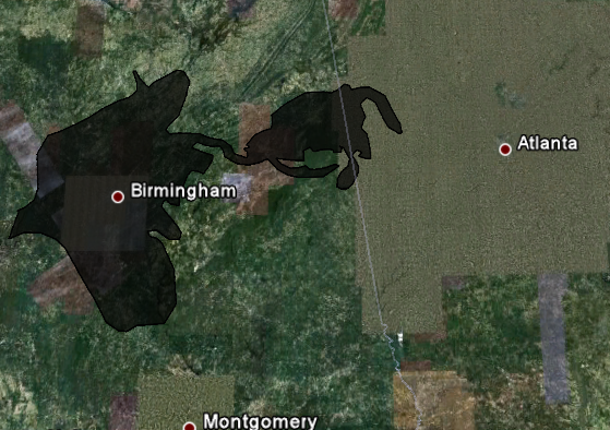
The black circle on the image up above helps you identify metro Birmingham on the map.

He published the data as part of providing a more exhaustive explanation of the findings he used to create an interactive map just before New Year’s Eve. Folks are getting a chance to dig into the data a little deeper courtesy of a post made yesterday to The Atlantic Cities.

It’s interesting when looked at in conjunction with the census tract data visuals we wrote about yesterday

This year, we bike FROM work!

Bike From Work 2012 RouteIt stands to reason that you’ll still have to bike TO work in order to participate in this year’s Bike from Work Day being organized by the Regional Planning Commission of Greater Birmingham (RPCGB) and the CommuteSmart initiative. It’s the ninth year that an event has been held though it’s the first time it’ll take place in the evening.

This year’s ride will once again start at the parking lot adjacent to the Young and Vann Building on 1st Ave. N. & 18th St. N. (home to both the RPCGB & CommuteSmart) but it will start at 5:30 p.m. If you want to take a closer look at this year’s route, click on the map to view the PDF or you can always download it from the page on CommuteSmart’s website that hosts additional information about the event.

It’s supposed to be a pretty comfortable day tomorrow (current forecast calls for a high of 77° and a low of 53° when we last checked – perfect cycling weather), so you may want to consider taking part if at all possible.

Time to SeeClickFix Birmingham

SeeClickFix logoA search of the site in recent weeks may have led you to a page labeled SeeClickFix (though there wasn’t anything on it). That changed last night.

That’s when we became the latest site to add a SeeClickFix widget. The service launched in late 2008 and we’ve been talking with them about its potential in Birmingham, AL since early 2010.

Think of it as a digital 311 system. Non-emergencies reported via the widget embedded on our site or via any of the mobile apps available are shared directly with City Hall’s 311 Call Center.

As you can see, folks are already using the service to report issues. The more folks using the service, the more effective it can be. Video and photo submissions are also accepted. Selfishly, it also provides an opportunity for local media outlets to get an idea of what’s going on out there (though nothing really replaces face-to-face – or just getting out there – but it helps).

Hop on over, check it out and spread the word!

We speak with a Lowland Southern dialect

dialect map screenshotYes, someone has created a map of North American English dialects, based on pronunciation patterns and it’s recently been updated.

It was developed by Rick Aschmann, a professional linguist and Christian missionary who grew up traveling back and forth between Mexico and the U.S.

The full map includes links to YouTube videos as well as audio clips of individuals thought to be representative of the specific area’s speech patterns.

Who are the folks used as examples for Birmingham, AL? There are three actually – U.S. Senator Richard ShelbyU.S. Congressman Spencer Bachus and retired Florida State University (and Woodlawn High School alum) Bobby Bowden (NOTE: the videos linked to are not necessarily the ones used by the site).

If you disagree with his findings, you can always contact him.

Screenshot of the North American Dialect map. Courtesy of website.

Could Homewood be poised to land a Target?

Targets in metro BirminghamThe Birmingham Business Journal is reporting that the city of Homewood is providing $10.4 million in incentives to Colonial Properties Trust – $1.4 million for road improvements and $9 to help Trust potentially lure Target to their Colonial Brookwood Village development (located along Lakeshore Drive between Highways 31 and 280).

The $1.4 million had been previously brought before Homewood’s City Council earlier in September though no action had been taken at that time. Representatives for Target in a story filed by The Birmingham News mid-August stated that no plans had been announced for a location in Homewood, Another story filed during that period suggests that the discount retailer was being sought by Colonial.

It would definitely reduce travel time for those located in metro Birmingham’s core. There are Super Targets located in Hoover (as of this posting the country’s largest),Trussville, and along Highway 280 and “regular” locations in Fultondale and Bessemer. Using our offices as a starting point, it would reduce our drive to the closest Super Target (280) by 5 miles and to the Fultondale location by three.

It would also not be the first time that future plans for the development had been discussed including a period in late 2006 when it was believed that a Westin hotel would be built on the property; despite an announcement, plans never materialized.

Map: Courtesy of Target.com search function.

How big is the oil spill? You don’t want to know…

Gulf Coast oil spill mapThat’s the question that the folks at Google decided to help people figure out. The image to your left is a screen capture from Paul Rademacher’s website and shows the spill in relation to the size of Birmingham and Central Alabama.

Rademacher’s site currently contains a Google Earth embed using the application’s API that lets you see how the oil spill compares to several major U.S. cities. Here’s a link to a screen capture of the oil spill in relation to Chicago, IL and Lake Michigan. He’s the engineering manager for Google Maps’ front end.

Visiting the site will also let you compare the size of the Deepwater oil spill to any city and points you to where you can download the data to show it in your own install of Google Earth.

UPDATE: Additional images – one showing the spill area in relation to Atlanta and Montgomery and another one showing the capture from when you first enter Birmingham, AL into the interface.

Image: Screen capture from http://paulrademacher.com/

What to add to Google Street view…

…that’s the question being asked by Google to all of us.

Would you add the grounds at the Birmingham Botanical Gardens? Linn Park? Rickwood Field? The Shades Creek Greenway? Well, here’s your chance to let the folks at Google know what venues in Birmingham, AL (and everywhere else) need to be added. You’ve got until October 28.

Plus, we’d get a chance to check out the Google Street View trike in person. That alone seems to be worth it…