


 Yes, there’s recently been a significant amount of focus on proposed plans for I-20/59. Diehards have been aware of the topic since last summer when the initial plan was presented at a public hearing only to be sent back (at the request of city and county officials – but more on that later). While much of the recent conversation has looked at cities currently going through similar effort, I thought it’d make some sense to look at one example where the battle’s been fought and the resolution is still a work in progress. Enter a rebuilt Fort Washington Way (FWW) in Cincinnati, Ohio – a creative approach to handling the passage of I-71 and U.S. 50 through the city adjacent to the waterfront.
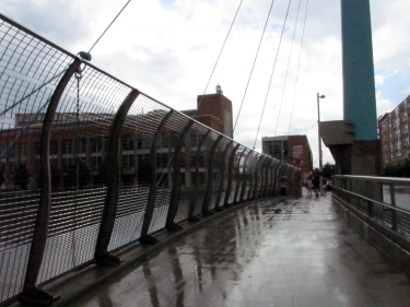
I’ve had the opportunity to drive FWW through Cincinnati often over the last 10 years. My most recent chance was late last month on the way back from a trip to upstate New York for a wedding. I’d watched its development play out online via Planetizen (an insane resource for planning and urban issues geeks) – though the older archives aren’t accessible anymore. Luckily, the folks at Urban Cincy did an incredible four-part series (1, 2, 3, 4) three years ago chronicling some of the foresight in this compromised solution up north. Cincinnati-Transit.net does an excellent job providing historical context for both the original FWW and the one used by area commuters today. I’d always wanted a photo of how they treated the narrower roadways over the road, as pictured above, meaning it was time to make a longer pit stop.
Getting better acquainted with the project has me wondering if we’re leaving out a few questions as we continue to talk about it. I’ll warn you I’m basing my thoughts and observations on the idea of sinking the interstate. The same questions apply if the road is shifted, albeit with a much broader range of results available. I’ll also point out the nonexistence of sexy, immediate solutions – as proven via this story about parking filed in 2009 – but it’s something to remember regardless of what happens.
Is it possible to complete the project in phases? The redevelopment of FWW in Cincinnati was part of a much broader redevelopment plan for the city’s waterfront. The same opportunity exists with the sinking proposal as it could allow for expansion of both the BJCC and the Birmingham Museum of Art either immediately adjacent to their current locations or close by. Our transit center is already destined for the southern edge of the city’s central business district, but it doesn’t mean we couldn’t be thinking about future needs as we continue a public conversation about it. The rebuilt road would simply be the first phase, with the access roads still possible along either side enabling a civic boulevard the likes of which we still need psychologically here in Birmingham. The current phase underway in Cincinnati includes a wide-ranging engagement of the public, making sure their ideas are considered and heard as officials determine exactly what goes on top of the roadway. I’m not as familiar with the situation surrounding air rights over I-20/59 (FWW is actually both I-71 and U.S. 50, something that enabled Cincinnati to maintain their air rights), so there’s still a question in my mind about what’s currently possible and what can be persuaded into being. It’s also important to point out that the city of Cincinnati was – and still is – considered the lead agency on the project.
Have we publicly discussed how the city may be able to “fill the gap” cost-wise? We know the alternatives will cost more money. We know there are a vast majority of people who want to see the alternatives seriously considered. We haven’t publicly floated any ideas about how to “fill the gap” between the cost ALDOT is willing to cover and the actual cost of any alternative built – at least not recently.
The additional license fees and taxes proposed and implemented by the Langford administration are still being collected. Maybe they can be used as a funding source? Is there a way to expand the tax increment financing (TIF) district already in place downtown, enabling some of the increased monies potentially available from recapitalization to go towards an alternative proposal’s construction? Maybe we look to the parking authority as a funding source (though that’s the subject for another piece – and a whole new cans of worms)? If we find out we can do whatever we want on the lids covering the sunken roadway, could we attempt to treat it as another Railroad Park – could we raise the money to fill the gap? A possible last minute issue in Cincinnati in 2000 resulted in demonstrating just what the business community and the city would be willing to contribute if it really wants to see this type of development occur, with funding sources more easily identifiable later on as residential development moved forward.
Do we know the whole story or just the most recent chapter? Something of significance is remembering the original proposal from ALDOT. When they held their first public hearing last July (the one that allows them to correctly claim four such meetings in the process), their plan consisted of shutting down traffic similar to what they’ve been doing for the stretch of road between Birmingham-Shuttlesworth International Airport and the I-459 interchange and simply replacing the decking. The reason we’re looking at the current unpopular plan is because both the city (with representatives from the mayor’s office in attendance at the public hearing after the request was made earlier that day) and the county asked for ALDOT to come up with something else – in part because there were many upset with the idea of simply repairing and retaining the status quo. Yes, existing proposals for sinking the road already existed, but for various reasons, they weren’t talked about as much as they needed to be at that time. We’re making up for lost time now, but we need to be sure we know everything, including recognizing the neighborhoods originally destroyed and affected by its initial construction. The recent debacle meeting at ALDOT headquarters with the city makes many of us wary and unsure – and with great reason…
As we move forward, it may help to look for answers to these questions and others. It could be the difference between getting what we want and getting what we need. After all, there’s no better way to show how much you believe in the importance of the project than by caring enough to ask the right questions.


More things to think about regardless of the I-20/59 conclusion
Now, I drive by the BJCC and Uptown every day. As a result, I’ve had several other questions on my mind in recent weeks as it relates to I-20/59 and ALDOT’s proposed changes. I’m sure someone’s going to get to these at some point, but I wanted to go ahead and get these thoughts out there too just to see what bubbles up from readers:
Where do the cars currently parking under the interstate go? A lot of cars will be looking for new places to park as a result of the currently proposed configuration and the closing of 9th Ave. N. A survey of spaces located between 18th and 23rd Sts. N. underneath the interstate and along 9th suggests at least 625 (and as many as 660) vehicles will need to figure out where to go (special thanks to the RPCGB for helping to gather this info so quickly) once this project begins to move forward. This, provided new development continues to occur adjacent to the BJCC begs a follow-up question:
Where do we build a new parking lot (or do we even need to build a new one)? Before we jump on the “we need to build a new deck” bandwagon, it may help to pause and look at the bigger picture. This may be the spark needed to implement an expanded shuttle service downtown. It may even encourage folks to use the existing service provided by the BJCTA. The idea of enabling commuters and visitors to park in one of the lots located along Morris Avenue or any of the existing parking decks maintained by the Birmingham Parking Authority is intriguing. On-street parking options are plentiful, but not sufficient for those visiting the museum or the BJCC and unable to check their meters continuously throughout the day. A shuttle only works is if you can get folks out of their current need of having to park as close to their location as possible. It’s something possible to accomplish if you made it a more logical (read – cheaper) option to park in the decks than on the streets (the way many cities approach managing their parking situations to free up on-street spaces for shorter visits to stores).
Is it time for directional signage citywide? We seem to like tackling the creation of gateways for the city; the recent tree planting at the 31st St. N. exit suggests the corporate community is willing to help the city put its best foot forward as we see increased visitors not just this year, but arguably over the next five as we continue to commemorate milestones in the civil rights movement. Wayfinding, however, has been an issue the powers that be have been discussing for a long time. The Medical District is the most recent section of Birmingham to attempt to tackle it. Individual sites and attractions have tried as well as they tire of waiting for a comprehensive solution to surface.
If we accept that the ramps will go away regardless of what happens, we can also admit it will provide an excuse for visitors and locals alike to explore not just greater downtown, but the entire city (if only because it’s now a possible “accident” waiting to happen). It’s a chance to make sure all are aware of the options and experiences available to them. It could also make it easier for folks to navigate an already insane grid system.
Speaking of the grid…
Is it time to wave “bye-bye!” to the one-way streets downtown? One of the reasons often given for the existence of one-way streets in Birmingham’s city center is because of the ability to get into and out of downtown as quickly as possible via the surrounding highways. The elimination of the ramps providing access to these thoroughfares could be the impetus to finally carry out a major recommendation of the 2004 City Center Master Plan – converting many one-way streets back to two-way. It’d probably be most helpful along those streets most affected by the proposed interstate changes – thoroughfares like 5th Ave. N., 18th St., 22nd St. and Richard Arrington, Jr. Blvd. As many hope to see more restaurants and stores move downtown to serve the estimated 80,000+ that venture in every day, it sure would be nice to make them more visible from multiple directions. It could even encourage more foot traffic – thanks to increased “eyes on the road” for peace of mind.
These are questions not necessarily considered when looking at the situation on its surface, but they will be ones where answers are more critical to the period of during and after construction of whatever happens. Ironically, the very thing the proposal aims to get to pass through the city quickly – the car – is the one thing that will lead to significant decisions to be made about how downtown will continue to adapt and change as it enjoys a national and international close-up.
7 Comments
Posted in Commentary, development
Tagged ALDOT, Birmingham, I-20/59, parking