 Yesterday I decided to point to a specific city that’s actually tackled an inner-city interstate replacement and use it to ask a lot of questions about our situation here in Birmingham. I think talking through the answers will go a long way towards how ALDOT chooses to respond to critics of their current alternative to their original proposal to replace the existing decking as it exists.
Now, I drive by the BJCC and Uptown every day. As a result, I’ve had several other questions on my mind in recent weeks as it relates to I-20/59 and ALDOT’s proposed changes. I’m sure someone’s going to get to these at some point, but I wanted to go ahead and get these thoughts out there too just to see what bubbles up from readers:
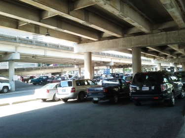
Where do the cars currently parking under the interstate go? A lot of cars will be looking for new places to park as a result of the currently proposed configuration and the closing of 9th Ave. N. A survey of spaces located between 18th and 23rd Sts. N. underneath the interstate and along 9th suggests at least 625 (and as many as 660) vehicles will need to figure out where to go (special thanks to the RPCGB for helping to gather this info so quickly) once this project begins to move forward. This, provided new development continues to occur adjacent to the BJCC begs a follow-up question:
Where do we build a new parking lot (or do we even need to build a new one)? Before we jump on the “we need to build a new deck” bandwagon, it may help to pause and look at the bigger picture. This may be the spark needed to implement an expanded shuttle service downtown. It may even encourage folks to use the existing service provided by the BJCTA. The idea of enabling commuters and visitors to park in one of the lots located along Morris Avenue or any of the existing parking decks maintained by the Birmingham Parking Authority is intriguing. On-street parking options are plentiful, but not sufficient for those visiting the museum or the BJCC and unable to check their meters continuously throughout the day. A shuttle only works is if you can get folks out of their current need of having to park as close to their location as possible. It’s something possible to accomplish if you made it a more logical (read – cheaper) option to park in the decks than on the streets (the way many cities approach managing their parking situations to free up on-street spaces for shorter visits to stores).
Is it time for directional signage citywide? We seem to like tackling the creation of gateways for the city; the recent tree planting at the 31st St. N. exit suggests the corporate community is willing to help the city put its best foot forward as we see increased visitors not just this year, but arguably over the next five as we continue to commemorate milestones in the civil rights movement. Wayfinding, however, has been an issue the powers that be have been discussing for a long time. The Medical District is the most recent section of Birmingham to attempt to tackle it. Individual sites and attractions have tried as well as they tire of waiting for a comprehensive solution to surface.
If we accept that the ramps will go away regardless of what happens, we can also admit it will provide an excuse for visitors and locals alike to explore not just greater downtown, but the entire city (if only because it’s now a possible “accident” waiting to happen). It’s a chance to make sure all are aware of the options and experiences available to them. It could also make it easier for folks to navigate an already insane grid system.
Speaking of the grid…
Is it time to wave “bye-bye!” to the one-way streets downtown? One of the reasons often given for the existence of one-way streets in Birmingham’s city center is because of the ability to get into and out of downtown as quickly as possible via the surrounding highways. The elimination of the ramps providing access to these thoroughfares could be the impetus to finally carry out a major recommendation of the 2004 City Center Master Plan – converting many one-way streets back to two-way. It’d probably be most helpful along those streets most affected by the proposed interstate changes – thoroughfares like 5th Ave. N., 18th St., 22nd St. and Richard Arrington, Jr. Blvd. As many hope to see more restaurants and stores move downtown to serve the estimated 80,000+ that venture in every day, it sure would be nice to make them more visible from multiple directions. It could even encourage more foot traffic – thanks to increased “eyes on the road” for peace of mind.
These are questions not necessarily considered when looking at the situation on its surface, but they will be ones where answers are more critical to the period of during and after construction of whatever happens. Ironically, the very thing the proposal aims to get to pass through the city quickly – the car – is the one thing that will lead to significant decisions to be made about how downtown will continue to adapt and change as it enjoys a national and international close-up.


 home/news | culture | opinion | calendar


More things to think about regardless of the I-20/59 conclusion
07.25.2013 by André Natta · → 7 Comments
Now, I drive by the BJCC and Uptown every day. As a result, I’ve had several other questions on my mind in recent weeks as it relates to I-20/59 and ALDOT’s proposed changes. I’m sure someone’s going to get to these at some point, but I wanted to go ahead and get these thoughts out there too just to see what bubbles up from readers:
Where do the cars currently parking under the interstate go? A lot of cars will be looking for new places to park as a result of the currently proposed configuration and the closing of 9th Ave. N. A survey of spaces located between 18th and 23rd Sts. N. underneath the interstate and along 9th suggests at least 625 (and as many as 660) vehicles will need to figure out where to go (special thanks to the RPCGB for helping to gather this info so quickly) once this project begins to move forward. This, provided new development continues to occur adjacent to the BJCC begs a follow-up question:
Where do we build a new parking lot (or do we even need to build a new one)? Before we jump on the “we need to build a new deck” bandwagon, it may help to pause and look at the bigger picture. This may be the spark needed to implement an expanded shuttle service downtown. It may even encourage folks to use the existing service provided by the BJCTA. The idea of enabling commuters and visitors to park in one of the lots located along Morris Avenue or any of the existing parking decks maintained by the Birmingham Parking Authority is intriguing. On-street parking options are plentiful, but not sufficient for those visiting the museum or the BJCC and unable to check their meters continuously throughout the day. A shuttle only works is if you can get folks out of their current need of having to park as close to their location as possible. It’s something possible to accomplish if you made it a more logical (read – cheaper) option to park in the decks than on the streets (the way many cities approach managing their parking situations to free up on-street spaces for shorter visits to stores).
Is it time for directional signage citywide? We seem to like tackling the creation of gateways for the city; the recent tree planting at the 31st St. N. exit suggests the corporate community is willing to help the city put its best foot forward as we see increased visitors not just this year, but arguably over the next five as we continue to commemorate milestones in the civil rights movement. Wayfinding, however, has been an issue the powers that be have been discussing for a long time. The Medical District is the most recent section of Birmingham to attempt to tackle it. Individual sites and attractions have tried as well as they tire of waiting for a comprehensive solution to surface.
If we accept that the ramps will go away regardless of what happens, we can also admit it will provide an excuse for visitors and locals alike to explore not just greater downtown, but the entire city (if only because it’s now a possible “accident” waiting to happen). It’s a chance to make sure all are aware of the options and experiences available to them. It could also make it easier for folks to navigate an already insane grid system.
Speaking of the grid…
Is it time to wave “bye-bye!” to the one-way streets downtown? One of the reasons often given for the existence of one-way streets in Birmingham’s city center is because of the ability to get into and out of downtown as quickly as possible via the surrounding highways. The elimination of the ramps providing access to these thoroughfares could be the impetus to finally carry out a major recommendation of the 2004 City Center Master Plan – converting many one-way streets back to two-way. It’d probably be most helpful along those streets most affected by the proposed interstate changes – thoroughfares like 5th Ave. N., 18th St., 22nd St. and Richard Arrington, Jr. Blvd. As many hope to see more restaurants and stores move downtown to serve the estimated 80,000+ that venture in every day, it sure would be nice to make them more visible from multiple directions. It could even encourage more foot traffic – thanks to increased “eyes on the road” for peace of mind.
These are questions not necessarily considered when looking at the situation on its surface, but they will be ones where answers are more critical to the period of during and after construction of whatever happens. Ironically, the very thing the proposal aims to get to pass through the city quickly – the car – is the one thing that will lead to significant decisions to be made about how downtown will continue to adapt and change as it enjoys a national and international close-up.
Filed under: Commentary · development