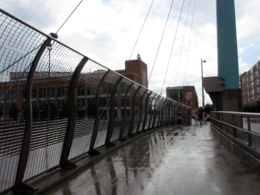
 Yes, there’s recently been a significant amount of focus on proposed plans for I-20/59. Diehards have been aware of the topic since last summer when the initial plan was presented at a public hearing only to be sent back (at the request of city and county officials – but more on that later). While much of the recent conversation has looked at cities currently going through similar effort, I thought it’d make some sense to look at one example where the battle’s been fought and the resolution is still a work in progress. Enter a rebuilt Fort Washington Way (FWW) in Cincinnati, Ohio – a creative approach to handling the passage of I-71 and U.S. 50 through the city adjacent to the waterfront.
I’ve had the opportunity to drive FWW through Cincinnati often over the last 10 years. My most recent chance was late last month on the way back from a trip to upstate New York for a wedding. I’d watched its development play out online via Planetizen (an insane resource for planning and urban issues geeks) – though the older archives aren’t accessible anymore. Luckily, the folks at Urban Cincy did an incredible four-part series (1, 2, 3, 4) three years ago chronicling some of the foresight in this compromised solution up north. Cincinnati-Transit.net does an excellent job providing historical context for both the original FWW and the one used by area commuters today. I’d always wanted a photo of how they treated the narrower roadways over the road, as pictured above, meaning it was time to make a longer pit stop.
Getting better acquainted with the project has me wondering if we’re leaving out a few questions as we continue to talk about it. I’ll warn you I’m basing my thoughts and observations on the idea of sinking the interstate. The same questions apply if the road is shifted, albeit with a much broader range of results available. I’ll also point out the nonexistence of sexy, immediate solutions – as proven via this story about parking filed in 2009 – but it’s something to remember regardless of what happens.
Is it possible to complete the project in phases? The redevelopment of FWW in Cincinnati was part of a much broader redevelopment plan for the city’s waterfront. The same opportunity exists with the sinking proposal as it could allow for expansion of both the BJCC and the Birmingham Museum of Art either immediately adjacent to their current locations or close by. Our transit center is already destined for the southern edge of the city’s central business district, but it doesn’t mean we couldn’t be thinking about future needs as we continue a public conversation about it. The rebuilt road would simply be the first phase, with the access roads still possible along either side enabling a civic boulevard the likes of which we still need psychologically here in Birmingham. The current phase underway in Cincinnati includes a wide-ranging engagement of the public, making sure their ideas are considered and heard as officials determine exactly what goes on top of the roadway. I’m not as familiar with the situation surrounding air rights over I-20/59 (FWW is actually both I-71 and U.S. 50, something that enabled Cincinnati to maintain their air rights), so there’s still a question in my mind about what’s currently possible and what can be persuaded into being. It’s also important to point out that the city of Cincinnati was – and still is – considered the lead agency on the project.
Have we publicly discussed how the city may be able to “fill the gap” cost-wise? We know the alternatives will cost more money. We know there are a vast majority of people who want to see the alternatives seriously considered. We haven’t publicly floated any ideas about how to “fill the gap” between the cost ALDOT is willing to cover and the actual cost of any alternative built – at least not recently.
The additional license fees and taxes proposed and implemented by the Langford administration are still being collected. Maybe they can be used as a funding source? Is there a way to expand the tax increment financing (TIF) district already in place downtown, enabling some of the increased monies potentially available from recapitalization to go towards an alternative proposal’s construction? Maybe we look to the parking authority as a funding source (though that’s the subject for another piece – and a whole new cans of worms)? If we find out we can do whatever we want on the lids covering the sunken roadway, could we attempt to treat it as another Railroad Park – could we raise the money to fill the gap? A possible last minute issue in Cincinnati in 2000 resulted in demonstrating just what the business community and the city would be willing to contribute if it really wants to see this type of development occur, with funding sources more easily identifiable later on as residential development moved forward.
Do we know the whole story or just the most recent chapter? Something of significance is remembering the original proposal from ALDOT. When they held their first public hearing last July (the one that allows them to correctly claim four such meetings in the process), their plan consisted of shutting down traffic similar to what they’ve been doing for the stretch of road between Birmingham-Shuttlesworth International Airport and the I-459 interchange and simply replacing the decking. The reason we’re looking at the current unpopular plan is because both the city (with representatives from the mayor’s office in attendance at the public hearing after the request was made earlier that day) and the county asked for ALDOT to come up with something else – in part because there were many upset with the idea of simply repairing and retaining the status quo. Yes, existing proposals for sinking the road already existed, but for various reasons, they weren’t talked about as much as they needed to be at that time. We’re making up for lost time now, but we need to be sure we know everything, including recognizing the neighborhoods originally destroyed and affected by its initial construction. The recent debacle meeting at ALDOT headquarters with the city makes many of us wary and unsure – and with great reason…
As we move forward, it may help to look for answers to these questions and others. It could be the difference between getting what we want and getting what we need. After all, there’s no better way to show how much you believe in the importance of the project than by caring enough to ask the right questions.


 I left
 There is sure to be a rather large crowd sitting in

Remember MAPS?
The more I did, the more I looked at the ability to point to specific accomplishments. I also thought about the issues still facing the metro region as the city begins the march towards its 150th birthday in 2021. Then I remembered a conversation I had during that 1998 visit about a yard sign I’d noticed about something called MAPS.
See, my visit to Birmingham for the tenth anniversary of City Stages in 1998 coincided with the beginning of a massive media blitz associated with the public referendum vote on the Metropolitan Area Projects Strategy legislation held on August 4 of that year. I’d try to explain it here, but the link provides a good summary of its goals. The vote was held, the initiative was defeated (except in, incidentally, the city of Birmingham), and life went on as always. Or did it?
When you start to look at the individual components of MAPS and the reasons we’ve been seeing all of this positive press, you begin to realize that time can be a valuable ally for those willing to wait, even for those who still have “The Future Can’t Wait” signs (perhaps playing off the title of a book birthed out of 1963 Birmingham). You also begin to realize just how much of our positive press can be attributed to those projects and what they encouraged.
There are some on a list maintained on BhamWiki of some of those projects listed in order of popularity based on a 1998 poll that seem to be a big reason for our recent success.
The McWane Science Center opened to the public just before the MAPS vote, meaning it was probably held up as an example of what the possibilities were for the region if the plan was approved. The major restoration of Vulcan and his home atop Red Mountain between 1999 and 2004 led to recognition by the National Trust for Historic Preservation in the form of a 2006 Preservation Honor Award.
The Birmingham Zoo did see its expansion, adding the Trails of Africa nearly 40 years after the development of a master plan that had suggested such a change. Ruffner Mountain learned this week it is included in the city council’s version of the 2014 budget as more trails are added to its more than 1,000 acres. Railroad Park anchors an emerging spine of a greenway through the heart of greater downtown. We just reported this week about the upcoming addition of the largest dog park in the city at Red Mountain Park in the city’s western area. The Red Rock Ridge and Valley Trail System hopes to tie it all together and already sees shovels in the ground.
The regional transportation hub is now called an intermodal terminal and it’s set to begin its rise next to the tracks along Morris Avenue late this year while just yesterday both this site and AL.com reported on the first major change to the law governing the BJCTA in more than 40 years. They also unveiled new buses on Thursday.
The Alabama Theatre underwent a restoration in 1998 and the community leaders are working feverishly to raise funds to finally begin restoration of the Lyric Theatre across the street. While it may not be ready in time for its 100th anniversary next year, the sight of construction crews working within will be a welcome one for those working across the street to renovate the former home of Booker T. Washington Insurance Co. into residential units.
The swimming and aquatic center got to see a track and field component added to it, resulting in the Birmingham CrossPlex in Five Points West. This is the same facility that landed the city the NCAA Division II diving, swimming, track and field, and wrestling championships this spring. Uptown is the realization of the first phase of the expanded convention center complex and entertainment district (though as Kyle Whitmire reported Thursday for AL.com, currently proposed changes to I-20/59 threaten those plans).
The 1% sales tax increase? It’s been implemented in piecemeal throughout the region in recent years (most notably – and controversially – via former mayor Larry Langford’s Birmingham Economic and Community Revitalization Ordinance in 2007, itself a mini-version of MAPS) as the need for the funding source has been realized. It is not the best approach towards raising the capital, but perhaps recent developments like the availability of a state historic tax credit for residential projects will help us see historic homes restored and occupied, leading to more property taxes being collected from a large population.
Yes, we have lost businesses and things haven’t always gone the city’s way. There is still much to be done in our outlying neighborhoods and our city center, but there are signs of progress that don’t necessarily involve waiting for elected officials to lead the way. Parking meters don’t work, sidewalks don’t exist, and lights are not always glowing at night. They must be dealt with, and soon. However, if we only dwell on those things, we’ll miss out on what has happened. Community gardens serving food deserts, signs of reinvestment in neighborhoods some wrote off. There are signs of belief in the future of the city – something I didn’t necessarily see on display in large amounts during that first visit or when I first relocated nine years ago.
Actual maps are a funny thing. They can tell you where you need to go, but they won’t always tell you about obstacles (or websites) in the way.
Most Sundays I write down the word “patience” on a prayer request card at church because I think I don’t have enough. I’d argue sometimes we don’t know what we have until it sneaks up on us – like an All-America City that still has issues to tackle, but one that’s come a long way from where it thought it would be fifteen years ago.
Just imagine if MAPS had passed? Scary, isn’t it? But we’ve still got a road map to follow, so let’s get to it. That is what’s changed – the increase in the belief in the perpetual promise of the city and the region.
André Natta is the stationmaster for bhamterminal.com.
Leave a comment
Posted in Commentary, regional