Category Archives: development

Did you know this ramp might go away?

22ndstebound
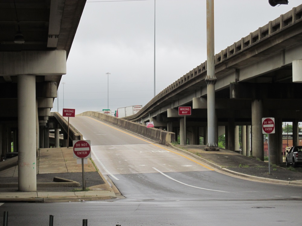
I left last night’s performance by Theaster Gates at the Birmingham Museum of Art with what’s become an impossible task. My plan was to write a piece about the most recent version of proposed changes for I-20/59, I-65, and 11th Avenue North. If you need a refresher (or a primer) on the issue, you may want to jump over to the piece talking about last week’s meeting in Norwood. After his powerful piece and the question and answer session last night, it got me wondering about the the deafening silence throughout metro Birmingham as they assume the project isn’t going to affect them. I was thinking about how much getting into downtown will change once the 22nd St. N. ramps (westbound pictured above) are gone.

Today is the posted last day for comments regarding the changes – ones that will do its part to effectively stifle burgeoning interest and investment in Norwood, Druid Hills, Fountain Heights, and the eastern edge of Smithfield. According to Nick Patterson’s Weld for Birmingham cover story, Brian Davis at ALDOT isn’t necessarily going to ignore those that come in later – but a lot will depend on the number of comments and their significance.

The plan derails any attempt to effectively continue expansion of the BJCC and its entertainment district. It also limits revitalization efforts in the Northside neighborhoods mentioned above. They serve an important role in renaissance currently enveloping the city center. I’d argue it’s a lot easier to demonstrate a need for long sought after amenities like grocery stores and drugstores when potential developers can point to additional rooftops less than two miles away as possible customers.

Realize this project, one currently slated to take three years, will also change traffic patterns in the city center – potentially causing additional issues as you go from north to south – even as it temporarily improves the flow of traffic through the region on the Interstate. I’m thinking specifically about the 11th Ave. N. modifications. They will create what amounts to a limited access road enabling folks to pass through in cars instead of stroll along a redeveloped area benefiting the city’s tax base and ensuring continued investment north of the Uptown entertainment district.

Think about how these changes will affect the morning rush hour. How about evening rush hour traffic? Now, think about that traffic as folks attempt to get to the BJCC with several events taking place at the same time?

This is the part of the metro area that’s seeing record attendance at the newest ballpark in all of baseball. This is the one that epitomes the significance of the medical industry as an economic engine for the state as Viva Health plans to raise its name atop the former Regions Bank headquarters.

Perhaps it would have made sense for ALDOT officials to pay attention to the comprehensive plan process already well underway when the agency held its second public involvement hearing in July. That said, It’s a lot easier for them to use the property they already control instead of attempting to move the Interstate from its current position. Imagine what happens if you’re driving north on I-65 had to deal with an extended Malfunction Junction – an interchange for I-20 at Finley Blvd., one at I-22, and finally at the looming specter of implied progress known as the Northern Beltline?

It’s not a pretty sight, is it? The alternative route wouldn’t be much better as traffic along Carraway Blvd. will see an increase regardless and those who’d be looking to avoid that potential jumble would have to consider growing populations in Gardendale and Fultondale.

It shouldn’t be left to just the residents of the city’s Northside to battle this plan. So an idea came up during a neighborhood meeting last week called to determine next steps:

“Why not place signs at the end of the ramps saying, ‘Did you know this ramp was going away?’”

I’ve had conversations with several people who didn’t know the ramps were going away. They were wondering how something like this could happen. It’s something you’d think state transportation officials would have considered before deciding to create more problems as a result of listening to request to look at alternatives to simply replacing the existing decking along I-20/59. That proposal wouldn’t remove the frustration of an implied boundary between the central business district and the BJCC property. It wouldn’t be creating this long-term morass instead of looking at a compromise that actually listens to the concerns of the entire Birmingham region.

We’ve got to fix our own problems – so long as Montgomery lets us. We have so much excitement currently captivating the hopes and dreams of residents who’ve long thought it would never happen for Birmingham. It’s weird to think a proposed solution to what is necessary evil of becoming a city built primarily for cars could have a chance to slow it down.

Why not let some more folks know about the ramps that won’t be there anymore (& the congestion that will result)? Go on…

André Natta is the stationmaster for bhamterminal.com.

Is it time for a cultural river through Birmingham?

There are a lot of people looking to tomorrow, 12/12/12, as a day of significance. It could be a day that marks a new chapter and an evolutionary leap for a community.

I’d argue a decision of that significance for the future of Birmingham was made late Tuesday morning when the Birmingham City Council reconsidered agenda item 34 at the end of their meeting.

That’s when they decided to unanimously approve the sale of Lot D, the site used as the muse for the Community Foundation of Greater Birmingham‘s Prize 2 The Future idea competition last year, to Alabama Power for $2.95 million– based on a recommendation from the city’s Budget and Finance committee. The redevelopment project that has been hinted at when talking about this purchase could include a conversion of the soon-to-be dormant steam plant currently operated across the street by the utility.

Many would find it hard to not agree the property’s location is not ideal or pivotal to the current level of activity underway south of the railroad tracks. Despite years of some disliking when Southside was referred to as downtown, it may become an essential part of its genetic makeup fairly soon. Those who remember the residential development known as The Standard originally slated to go across from Railroad Park at 18th St. well before the urban oasis was completed may notice soil is being moved, perhaps suggesting it may yet move forward, in some form, soon. Keep in mind that Rev Birmingham (formerly ONB/MSB) has promised upcoming announcements about two residential projects close to the park in their recent newsletter.

It got me wondering about what kind of project could be capable of continuing the transform the City of Birmingham. I started thinking about the areas surrounding the parks that Railroad Park are often compared with and found a common theme – one that could lead to a proposal as transformative as the ones considered during last year’s idea competition.

While folks like to compare Railroad Park to New York City’s Central Park, there are many native New Yorkers who’d find Bryant Park a better comparison and one that leads to far more potential. The park acts and looks like more of a living room than most, allowing for an outdoor reading room, movie screenings, fashion shows. The first use included in that list is made possible in part because of the park’s next door neighbor, the main branch of The New York Public Library.

A similar situation is found at Chicago’s Millennium Park, as its eastern edge is defined by The Art Institute of Chicago. There are other examples of civic cultural institutions anchoring gathering spaces throughout the country.

This is why seeing two people who were in attendance at today’s meeting made me think of a crazy idea for  Alabama Power’s rumored project – Kate Nielsen, the Community Foundation’s executive director, and Gail Andrews, the director for the Birmingham Museum of Art.

Ms. Nielsen spoke in support of the sale of the property at Monday’s committee meeting, with the Foundation posting a supportive statement on its site yesterday afternoon. Ms. Andrews enjoys overseeing the largest municipal museum of art in the Southeast, though at times at least 60% of the collection is not available for viewing. An expanded home or an opportunity to establish a second location (similar to what the Guggenheim Museum was able to do in New York years ago), would be extremely beneficial, especially as the eyes of the world turn to Birmingham in the coming months.

Birmingham's Railroad SkylineThere are others that could benefit from such an opportunity – including the Birmingham History Center (though it would still be pretty cool to see them end up at The Powell School long term). All in all, it would enable a cultural stream to run through the middle of our greater downtown area – the ballpark, Railroad Park, Line Park, Sloss Furnaces – connecting our city’s present (an expanding medical-based economy) with the heart of it’s central business district. Now think about it expanding west…

You may not be able to float down that stream per se, but imagine the potential dreamers such an idea could influence and inspire in our fair city? It’s potentially enough to help drive a transformation…

André Natta is the stationmaster for bhamterminal.com

The Cola Wars via Birmingham's billboards

Two North Twentieth through the walls at Regions Field.Yes, this is a photo of construction at Regions Field along the first base wall, taken early Friday morning. They’re doing an incredible job considering they’ve got approximately 120 days until Opening Day.

It’s not so much the construction efforts I was trying to capture but the potential view for those in attendance. It’s something to think about as you take your seats in April.

I’ll explain…

I probably wouldn’t have paid attention to it if I hadn’t been reminded about a story filed by Joseph Bryant for The Birmingham News this past June. That’d be when he wrote about the partnership between the City of Birmingham and Birmingham Coca-Cola Bottling Co. – the one that provides the largest privately-held Coca-Cola bottling company in the country exclusive serving rights at the Crossplex and Legion Field.

Why is this important?

Well, consider the fact that Regions Field will be a city-controlled facility. This would lead many to logically conclude that Coca-Cola will get exclusive serving rights inside the new facility. It also means that you’ll more than likely see signage reflecting this throughout.

A photo shared on Facebook via the Barons’ fan page on Tuesday starts to illustrate a couple of things. You can make out the iconic sign atop Two North Twentieth at the far right edge of said photo. This would be the same sign that’s been before the city’s Design Review Committee on three separate occasions in the last two months (an account of the most recent appearance is available over on Magic City Post). Here’s one of the most recent proposals:

The company responsible for managing the property, Harbert Realty Services, would like to lease it as a large static billboard space to Buffalo Rock for an extended period of time while they raise the funds needed to replace it with a modern LED display. The proposed sign wouldn’t reference Buffalo Rock however; it would contain the iconic Pepsi logo. You’d be able to see it from Malfunction Junction, Red Mountain Expressway, and potentially from inside Regions Field if you’re sitting along the first base line.

Let’s take a moment to think about the number of Coca-Cola billboards currently located in downtown Birmingham. There are four of them – two located along I-20; one located along I-65 (visible as you’re traveling northbound); another located along Red Mountain Expressway as you pass the 2nd Ave. N. exit ramp.

Now how many are associated with Buffalo Rock products? One – located along Red Mountain Expressway before you pass under Highland Avenue on Southside heading northbound. Incidentally, if you didn’t know that Dr. Pepper is distributed by Buffalo Rock, you do now, as it’s the brand featured on this sign.

I won’t even get into the huge Coca-Cola sign most travelers see as they take-off and land at the airport… (It is pretty cool though.)

Don’t get me wrong – there’s nothing wrong with iconic signs sitting outside of ballparks. The most well-known is the one Citgo continues to maintain just outside of Fenway Park in Boston. There is, however, a precedent that suggests the proposed sign here should not be approved as presented. I’m not the only one taking that position either.

It may also be a pure coincidence that there’s been three attempts to get some version of a Pepsi billboard approved by the committee.

Might it not make more sense to use the opportunity to demonstrate your significance as a corporate leader by asking for a display that celebrates the history of our city? Buffalo Rock used to have a very prominent sign in the City Center when it was located within its boundaries. It just happened to reference the flagship product. Maybe it could recognize or inspire us to truly look 50 years forward as visitors from around the world gather in Birmingham not just next year but throughout the next five years?

There’s also the issue of the cost of replacement which depending on which available online calculator you use; this one suggests it can get costly, quick.

It’s also not as if the city hasn’t been trying to reduce the number of billboards in the city. It was stated during a recent Design Review Committee meeting that significant progress had been made – and that the sign atop Two North Twentieth has been grandfathered in under current ordinances.

One hopes that maybe they’ll get the message – and that it won’t have to be posted onto a billboard first in order for them to notice.

André Natta is the stationmaster for bhamterminal.com

Musings on a bridge to somewhere

Looking towards downtownI went for a run recently at Railroad Park – the newness of being able to say that still hasn’t quite worn off yet. I tend to stay on the cushioned portion of the trail circling the four-block urban oasis. I decided I’d stop at the stairs that take you down to the portion of the trail that leads you along the lawn before rising again. It’s approximately where Mayor Bell’s bridge would connect 16th Street North with the park and Southside.

After I stopped thinking about how crazy it would be to run through the potential foot traffic, I started wondering what other reasons there could be for constructing this bridge – provided the feasibility study recently approved by the Birmingham City Council says it makes sense and the funding sources are identified and tapped. It’d be nice for tourism, but there are some more practical reasons that can be shared with the community that speak to its long term effects.

Here are a few that came to mind:

A symbolic gesture towards the future. Yes, this is the case already being presented by its proponents. Next year the spotlight will be focused on Alabama’s Magic City as people from across the country and around the world look to see what’s changed since September 1963. There will be just as many wondering who’ve never paid attention before wondering what’s happening in this city. Even though it wouldn’t be finished in time, it would be the type of civic project that could be pointed to when asked how things are progressing (though Railroad Park and the baseball field would do a pretty good job on their own). That’s nice, but it’s probably more of a symbolic gesture for the region’s residents than it is for outsiders.

Despite the best efforts of some locals, the days of the city’s central business district alone serving as the city’s downtown is over. It is “greater downtown Birmingham” nowadays, and it includes Southside. If we’re not going to be able to get an interstate sunk, we’re still going to want to go over something to claim success of truly connecting our city – and showing what else is possible as these cracks continue to be repaired. It also gives us a way to hearken images of the Walnut Street Bridge in Chattanooga as we cross our “river” running through the center of town (I know that’s running through some minds out there, admit it).

It’s a businessperson’s special. When I lived downtown, I used to prefer running over the 22nd St. bridge to attempting to go under the railroad tracks on 20th St., despite that being where signs currently live guiding runners new to the city through it. Considering I could run a little faster when I first moved here, occasionally switching up the route didn’t phase me that much – especially on hot evenings where it did provide a cool respite. Now imagine a bunch of folks who drive into town solely to work in the city’s central business district who’d rather walk over something rather than under while in town for a game – and who’d rather park somewhere familiar to them. It suddenly opens up a lot more parking options for the ballpark too, doesn’t it? Not to mention the potential foot traffic. This leads to…

The UAB/Bridge to the future angle. The state’s largest employer occupies a significant portion of the property south of the railroad tracks and a concerted effort needs to be made to encourage those associated with UAB to travel just a little farther north. This becomes much more important as people begin to realize how much land is available for redevelopment in the area known as the Entrepreneurial District – a portion of the city center with an easternmost boundary of 16th Street North. As efforts begin to encourage additional, denser development of the area, you’d love to offer them a really cool way to get to those games in addition to giving students and employees a reason to head towards downtown on foot – and thereby providing additional numbers to consider when attracting new businesses.

Looking towards ChildrensI’m really not saying we should or we shouldn’t do this bridge; I’m asking folks to be willing to look at several reasons for the project and to start having slightly deeper conversations about it and everything else you hear about going on in town right now. We already seem to be building a bridge to somewhere for this city. It’d be nice to start taking a look at just where it can possibly go and where it can take us once we’ve built it. This study is the latest step in that movement.

It also doesn’t hurt that each of these reasons point to a group that could help the mayor win re-election next year – provided he runs…

I just offered up three of the crazy reasons I thought of just standing there. Perhaps you’ve got some others (or maybe you think mine are silly). If so, share those thoughts and ideas below.

André Natta is The Terminal’s stationmaster.

Making tracks towards the future on Southside

1st Avenue Cut, May 16, 2012.A drive along 1st Avenue South heading east contains a significant yet subtle development for those able to stop and take a look. You’ll notice the absence of rails and ties both in the area known as the 1st Avenue Cut between 20th & 24th Sts. and between 28th and 32nd Sts.

A quick look at Birmingham’s GIS map shows most of the property in question being held by CSX. If you can’t tell, I started getting that nagging feeling again (you may have seen what happened earlier this week when that starts), and for some pretty good reasons.

The parcels in question have been identified on several occasions as essential for the “Plan A” expansion of Railroad Park. This would eventually connect the existing park between 14th and 18th Streets South and the property sitting on the northwest corner of 1st Ave. S. and 18th St. that served as the focus of “Prize 2 the Future” contest to Sloss Furnaces.

The native New Yorker who reads way too many online publications from there every morning remembered the transportation company had already agreed in principal to donate the property necessary to complete the city’s High Line back in late 2011. They donated the property developed as the first segment of the park back in 2005. They also have a history of donating property across the country to recreational projects and those that focus on alternative transportation solutions. Attempts were made to hear the reason for the track removal from CSX via email last week; there has still not been a response.

It doesn’t hurt that by removing the track they’ve enabled the city to be able to claim that this project is shovel-ready for development as part of the Jones Valley Corridor. It’s considered an integral part of the Red Rock Ridge and Valley Trail System unveiled earlier this year by the Freshwater Land Trust.

This becomes significant when you realize they’re going to announce what projects across the country have been awarded TIGER grants pretty soon – even sooner than some may realize. A bid was submitted for this round to help “jump start” some area projects; it’s the second attempt to secure these federal funds to assist with the greenway initiative.

There’s also the amount of activity currently taking place close to 32nd St. and 1st Ave. S to consider. We’re anxiously awaiting more information about the upcoming groundbreaking for Sloss’ new visitors center, a project many years in the making. Those who driving by IMS‘ properties close to Sloss’ entrance notice Appleseed Workshop signs up and a significant transformation underway to make this section of town resemble the master plan the company unveiled a couple of years ago for the Sloss Business District.

When you consider the demand for the monies awarded is far exceeding the supply, the cumulative effect of all of these things happening at once suddenly gives you hope for our chances of being awarded funds. Even if it’s not awarded, there’s been a shift in momentum for this area of the city – one that’s sure to pick up steam. It’s a perfect opportunity to focus on the concept of accentuating the city positive I talked about on here a couple of years ago.

Nice, isn’t it.

André Natta is the station master for bhamterminal.com.

A network to build a future of Birmingham on

UPDATE: The plan and its name – The Red Rock Ridge & Valley Trail System – was announced this evening – along with a website that allows you to see the entire plan.

A possible Norwood greenway gatewayThe photo you’re looking at off to your left probably doesn’t mean a lot to you right now. But it may mean something to you a little later on, especially if you feel like dreaming…

It’s safe to assume that this evening (Tuesday) a large crowd will be gathered in the Steiner Auditorium at the Birmingham Museum of Art. They’ll be there to witness the unveiling of the Freshwater Land Trust’s “Our One Mile” plan. They’ll also be among the first to learn the name of the system – the result of a contest held at the end of last year. The level of excitement filling the space will undoubtedly be insane.

Well, this is where I bring up one more thing to keep in your mind as we get started – the under-construction Greenwood Park. Folks that normally travel along I-20/59 westbound that have wondered why all those bulldozers have been active just after you pass Tallapoosa St., here’s your reminder. This new green space could be viewed as a trail head for the 26-mile Village Creek Greenway, a project viewed by many as an integral part of the Our One Mile initiative.

You’re starting to connect the dots, aren’t you? These first two have been brought up before, courtesy of the Norwood Plan developed by Auburn University’s Urban Studio back in 2006.

The park would connect with the greenway, which could hypothetically have another touch point along Vanderbilt Road. That connection would just happen to be about ¼ of a mile from the easternmost edge of Norwood Blvd – and be right about where that photo I told you to pay attention to at the beginning of this piece was taken.

Assuming there’s access to the greenway at Vanderbilt, it’d only be a little over ½ a mile along the creek to get to the edge of Greenwood Park that touches Coosa Street. I’m not even focusing on the fact that this could potentially bring a whole new group of users over to Patton Park on the other side of the Interstate.

What does all of this mean?

It means more once you include the recent donation by Red Diamond – their former headquarters on Vanderbilt Road (valued at approximately $2 million in an online listing) to the Birmingham YMCA.

The distance from the edge of Norwood Blvd. to 1701 Vanderbilt Road is approximately half a mile. If you’re running, this means you’re probably no more than 5-7 minutes away.

It could be the jump start  needed to encourage potential investors to take a look at the section of Norwood referred to by some in the neighborhood as “the bottoms” as an option for renovation projects. It’s safe to say there would be several young professionals that aren’t looking for a mortgage but instead for an inexpensive place that’s relatively close to downtown and some of those intangible quality of life benefits.

It might also lead to some changes in traffic flow in the area surrounding all of these things – changes that could influence whether or not we see significant development along 12th Avenue North, particularly the eastern end of the street. The western edge may already see some influence from a entertainment district that will soon go from dream to reality in the coming months.

It’s just an example of what happens when the dreams of a community are thought through and given the potential to be realized. It’s all out there – including pieces like Ruffner Mountain, Red Mountain Park, and the (soon-to-be-added-onto) Shades Creek Greenway. Now it’s simply time to see if folks want to connect those dots all the way.

Many of these thoughts about the northside are assuming that the YMCA decides that it can move ahead and make the additional improvements to their newest piece of property – suddenly the largest of the properties held by the organization. It also depends on how empowered and motivated the citizens of metro Birmingham get to make this greenway plan presented this evening a reality.

That last sentence is probably the most important one. As Wendy Jackson said in this morning’s Birmingham News piece by Thomas Spencer,

People need to be a voice for their greenways.

The days of people waiting for someone to take the lead need to end soon. As former UAB president Dr. Joseph Volker once stated, “We would do Birmingham a great disservice if we dreamed too-little dreams.”

This greenway – and many projects like it currently in the pipeline – are probably what Volker may have been thinking of as he spoke. It’s now up to the general public to lead the leaders to the city they want, rather than have a disjointed one given to them instead.

Maybe coming out to the event tonight’s a good first step.

André Natta is the stationmaster of bhamterminal.com.

Where will the road lead Carraway, Lovelady?

Something that seems to escape the minds of many of the people from all sides of the continuing debate about a future use of the former Carraway Hospital complex is the significance of 24th St. It may mean nothing to those who don’t normally find themselves exploring the Magic City during business hours, but it should.

See, 24th Street is one of the few that connects the area near the entertainment complex with points east. Specifically, you can drive 24th Street from the back side of the Carraway property and eventually you’d end up on Montclair Road (formerly U.S. 78) and eventually Crestwood Boulevard (the current U.S. 78). This also means it’s one of the only non-Interstate routes out to The Shops at Grand River (though that’s the topic of another post…).

A city that has a love/hate relationship with highways may not see the immediate impact of this situation. The same cannot be said for a city working to become a 21st century hub for the southeastern United States. If you don’t believe there are folks working towards that end, I’d invite you to check out the progress of the Birmingham International Airport modernization and expansion as well as the continued planning underway for a transportation hub downtown.

just over the ridgeIt’s a fun view for that split second – the one that you get to enjoy as you reach the crest of the road right after Montclair becomes Country Club (which is before it becomes Pawnee and then Niazuma) as it brings folks into the city of Birmingham. The nighttime approach into the city center has become even more colorful with the recent addition of Children’s Hospital‘s newest building.

The street immediately turns into 26th Street South as you pull alongside Caldwell Park and the Virginia Samford Theatre. The fork in the road ahead has you follow what is now 24th Street South through Southtown and towards points north.

Those who frequent this route have noticed that the Citgo gas station on the southwest corner of 24th Street and 6th Avenue South has recently re-opened, complete with a grocery. Folks who follow the happenings of the city’s Design Review Committee are probably waiting with intense anticipation as WorkPlay finally opens itself out onto 23rd Street with its new patio.

Once you cross the bridge into what’s long been known as the “loft district” you meet an opportunity to convert Jeremy Erdreich‘s architecture firm into anything right now, including perhaps another restaurant to take advantage of the success that’s been enjoyed by the likes of Urban Standard, Rogue Tavern and (already) El Barrio.

As you pass the always full parking lot of the city’s main U.S. Postal Service branch on your east, Fife’s is serving food on your left while the Stonewall Building waits for a proper tenant. The shell of the former Powell School waits too – and it is getting cleaned out in anticipation of its next act.

Phillips Academy sits on your left as you drive through the with Jones Valley Urban Farm just a couple of blocks over to the east. As you come out from under the Interstate you notice the entertainment district and its Westin Hotel centerpiece rising to the west. If you continue up the road you eventually run into the back end of the former Carraway Hospital property (after passing by a pharmacy and medical office that serves the surrounding community).

Physicians Medical Center Carraway. dystopos/FlickrI’ve written before about the significance of the Carraway property as it relates to I-22 and I-65. The fact that it’s a terminus for one of the few eastern corridors for the region should probably be an even more important argument made. Especially since I didn’t necessarily point out everything that’s currently going on.

Depending on which piece of property you look at, the traffic count for the Montclair portion of the passage ranges from 11,000 to 17,000 a day.

It’s easy to understand why that’s the case, especially when you realize that even when (or if) Trinity makes the move to Highway 280, there will be continued traffic thanks to the folks living in Crestwood South, and folks frequenting businesses in Crestline Village and the area surrounding Eastwood Village.

Those trips are already commonplace, including ones into the city center for work. If people are in the mood to avoid the Interstate to get to the Marketplace, or if one of those proposed $22 million developments get built, the number of cars will no doubt only increase.

The eastern edge of this development was once considered important – the glow of the signs and lights along Crestwood Boulevard as I approached Birmingham from the east for my first visit back in the late 90s was a clear message to all those that questioned the city’s potential.

For the Carraway terminus of this stretch of road, I’m now left wondering what folks driving to and around the entertainment district will see as a result of wanting to do some exploring (read: searching for a parking spot).

Time will tell if others are thinking about this too.

André Natta is the stationmaster for bhamterminal.com.